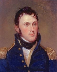
Stephen Harriman Long was an explorer, engineer, and inventor. Born in Hopkinton, New Hampshire, in 1784, Long attended Dartmouth College and went on to become a professor of mathematics at the U.S. Military Academy. He served as an officer and civil engineer in the Corps of Topographical Engineers for the U.S. Army and participated in a number of expeditions between 1816 and 1824 before working with railroads, bridge construction, and river navigation improvements.
Long was selected to lead an exhibition to survey potential sites for Army forts west of the Mississippi River in 1817. Based on his recommendations from the journey, the U.S. Army established Fort Smith on the Arkansas River and Fort Snelling at the Mississippi and Minnesota Rivers. Later in 1860, Long wrote of his experiences from this exploration in Voyage in a Six-oared Skiff to the Falls of St. Anthony in 1817.
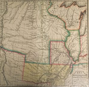
Long went on to command a group of engineers for the Yellowstone Expedition of 1819 when Secretary of War John C. Calhoun proposed to build a fort on the Yellowstone River, an expedition that marked the first use of steamboats on the Missouri River. This expedition was abandoned when the soldiers became ill with fever and scurvy during the winter near Council Bluffs, but Long’s mission was immediately replaced with a new expedition west in 1820 for which he is best known. Long and his party were tasked to explore the headwaters of the Platte, Arkansas, and Red Rivers. On this trip Long traveled into the Front Range of the Rocky Mountains, and his map from the journey coined the name “the Great American Desert” for the Great Plains east of the Rocky Mountains. Edwin James, a physician in Long’s party, wrote the official report of the expedition.

In what is now Colorado, they surveyed and named Long’s Peak, and several members of the party climbed Pike’s Peak. Shortly after, the expedition split into two groups: one traveled down the Arkansas River, and the other, led by Long, went in search of the Red River, which was the boundary between the United States and Spanish Mexico at the time. They found a river that they believed was the Red, but it was actually a tributary of the Arkansas River.
In 1823 Long led another expedition to the northern United States to find the sources of the Minnesota River and explore the United States-Canadian border to the west of the Great Lakes. He traveled up to Lake Winnipeg in Canada and then came back to the United States through the Great Lakes.
In the years following these major expeditions, Long became interested in the development of the railroad. The War Department assigned Long to find a route for the Baltimore and Ohio Railroad in 1827, and his survey resulted in a railroad manual that charted grades and curves along the route. He also consulted for railroads as an engineer and wrote several books on railroad and bridge construction. Long patented a method of building wooden bridges, as well. He continued his work with the Army during this time, and a reorganization of the Topographical Engineers had him working out of Louisville, Kentucky, on projects to improve navigation of the western rivers. In 1856 he was in charge of these improvements for the Mississippi River. He moved to Alton, Illinois, where his four brothers had settled, in 1858. Long retired in 1863, and he died in his home in Alton on September 4, 1864.

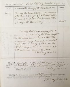
The Stephen Harriman Long Financial Records, 1852-1862 (MS 845) contain documents regarding Long’s work directing projects to survey and map western rivers. Part of this entailed creating and deploying boats and dredges to remove sandbars and other obstructions in the water like rocks, trees, logs, or wreckages that could damage steamboats. The records in this collection include information about Long’s projects, the services performed, vouchers, and the scope of the endeavors.
You can also read more about Long’s explorations from the IHLC’s Account of an Expedition from Pittsburgh to the Rocky Mountains (Call number: 917.8 J232a) and Narrative of an Expedition to the Source of St. Peter’s River, Lake Winnepeek, Lake of the Woods, &c. (Call number: 917.7 K22N), and you can view Long’s Map of Arkansas and other territories of the United States (Call number: G4040 1823 .L6).
Other Resources
Bartlett, Richard A. “Long, Stephen Harriman (1784–1864).” The New Encyclopedia of the American West, edited by Howard R. Lamar. Yale University Press, 1998. http://proxy2.library.illinois.edu/login?url=https://search.credoreference.com/content/entry/americanwest/long_stephen_harriman_1784_1864/0?institutionId=386
Lagasse, Paul. “Long, Stephen Harriman.” The Columbia Encyclopedia, 8th ed. Columbia University Press, 2018. http://proxy2.library.illinois.edu/login?url=https://search.credoreference.com/content/entry/columency/long_stephen_harriman/0?institutionId=386
“Stephen Harriman Long.” Explorers & Discoverers of the World. Detroit, MI: Gale, 1993. http://link.galegroup.com/apps/doc/K1614000190/BIC?u=uiuc_uc&sid=BIC&xid=c4b1f887
Van Horn, Lawrence F. “Exploration and Explorers.” Encyclopedia of the United States in the Nineteenth Century, edited by Paul Finkelman. Gale, 2000. http://proxy2.library.illinois.edu/login?url=https://search.credoreference.com/content/entry/galeus/exploration_and_explorers/0?institutionId=386
