Please join the International and Area Studies Library for the following event:
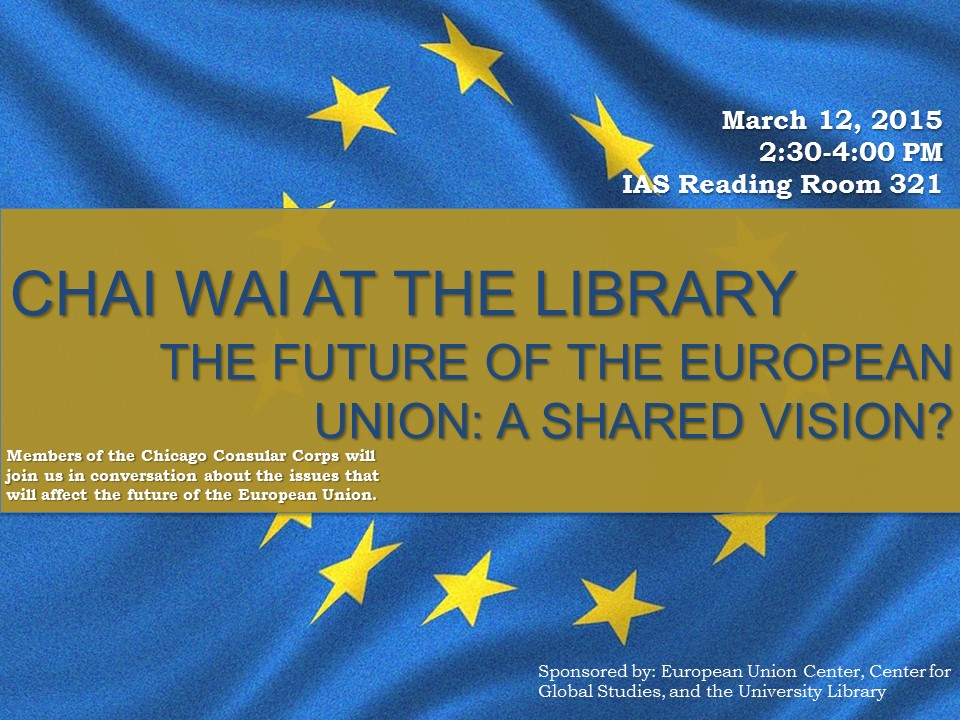
The event will include members of the Chicago Consular Corps in a conversation related to issues affecting the future of the European Union. In anticipation of this event, explore some of the important background information about the European Union, then join us for “Tea or something” on March 12, from 2:30-4:00 p.m. at the International and Area Studies Library, Room 321 Main Library to engage in the conversation. The discussion is sponsored by the European Union Center, the Center for Global Studies and the University Library.
Origins of the EU
The European Union traces its roots to the aftermath of World War II, when the countries of Europe were seeking solidarity to protect against further discord and war. The economic fallout from the war was immense, and this was also a motivating factor in creating organizations to unite the countries of Europe. In 1949, the Council of Europe was created when ten states ( Belgium, Denmark, France, Ireland, Italy, Luxembourg, the Netherlands, Norway, Sweden and the United Kingdom) signed the Treaty of London. With the aim “to achieve a greater unity between its members for the purpose of safeguarding and realising the ideals and principles which are their common heritage and facilitating their economic and social progress” (Statute of the Council of Europe), the Council became the first pan-European organization. The Council of Europe now includes every European country except for Belarus, Kazakhstan, and Vatican City.
The Three Communities
In 1950, Belgium, France, Germany, Italy, Luxembourg and the Netherlands founded the European Coal and Steel Community (ECSC), which merged the coal and steel sectors of member countries, ensuring that none could create weapons of war to use against the others. In 1957, these same six countries signed the Treaties of Rome, which created the European Economic Community (EEC) and European Atomic Energy Community (Euratom). The purpose of the EEC was to merge the economic markets of member countries, and Euratom merged the atomic energy industries of member countries. In 1967 ECSC, EEC, and Euratom joined to become European Communities. In 1973 Denmark, Ireland and the United Kingdom (with Gibraltar) joined the European Communities. These countries were followed by Greece (in 1981), and Spain and Portugal (in 1987).

By Kolja21 (Own work) [CC BY-SA 3.0 (http://creativecommons.org/licenses/by-sa/3.0) or GFDL (http://www.gnu.org/copyleft/fdl.html)], via Wikimedia Commons
In 1993, the Treaty of Maastricht officially created the European Union, which consists of three pillars: “the European Communities, common foreign and security policy and police and judicial cooperation in criminal matters” (Europa). The EU currently includes 28 countries. One goal of the Treaty of Maastricht was the creation of a common currency within the European Union. In 1999, the Euro became this common currency and the European Central Bank was launched.
Financial Crisis
In September of 2008, the global financial crisis hit Europe and the rest of the world. Specifically, the financial recession affected the European Union by inciting what is known as the Eurozone Debt Crisis, wherein some member states were unable to repay or refinance government debts. This led some countries (Greece, Ireland, Portugal, and Spain) to receive bailouts from the International Monetary Fund, the European Commission, and the European Central Bank. Some countries, such as Greece, are still suffering economic decline and possible default. The causes and effects of the Eurozone crisis are complex and still being debated today.
What’s Next?
Join the Chai Wai discussion on March 12 to explore some of the current issues facing the European Union. Check out the resources below to study up before the event!
Web Resources
Europa – Official Website of the European Union
Eur-Lex Access to European Law
European Union – News – Guardian
Euro Debt Crisis Explained – Economics Help
Scholarly Articles (Available through UIUC Online Journals and Databases)
Demosthenes Ioannou, Patrick Leblond & Arne Niemann (2015) European integration and the crisis: practice and theory. Journal of European Public Policy, 22:2, 155-176.
Deutschmann, Christoph. (2014). The future of the European Union: A ‘Hayekian’ regime? European Journal of Social Theory, 17(3), 343–358.
Francis Cheneval, Sandra Lavenex & Frank Schimmelfennig (2015) Demoi-cracy in the European Union: principles, institutions, policies. Journal of European Public Policy, 22:1, 1-18.
Grecu, Silviu Petru; Margarit, Diana. (2014). The instability of the European Union? A quantitative approach. Eastern Journal of European Studies, 5(1), 21-37.
HUIDUMAC-PETRESCU, C., & POPA, A. C. (2014). WHAT WAS NOT RESOLVED BY THE ANTI-CRISIS STRATEGIES IN THE EUROPEAN UNION. Hyperion International Journal Of Econophysics & New Economy, 7(2), 369-377.
Books (Available at UIUC Library)
Toemmel, Ingeborg. (2014). The European Union: what it is and how it works. Houndmills, Basingstoke, Hampshire ; New York, NY : Palgrave Macmillan.
Baimbridge, Mark,Whyman, Philip. (2015). Crisis in the eurozone: causes, dilemmas and solutions. Houndmills, Basingstoke, Hampshire ; New York, NY : Palgrave Macmillan.
Champeau, Serge. (Eds.) (2015). The future of Europe :democracy, legitimacy and justice after the Euro crisis. London ; New York : Rowman & Littlefield International.
Chang, Michele,, Menz, Georg, Smith, Mitchell P.. (Eds.) (2015). Redefining European economic governance. London ; New York : Routledge.
Kelemen, R. Daniel,, Menon, Anand,Slapin, Jonathan B.. (Eds.) (2015). The European Union: integration and enlargement. Abingdon, Oxon, UK ; New York, NY : Routledge.
