Ongoing Projects
-
Adapting Urban Drainage Infrastructure to Extreme Weather in the context of Changing Climate
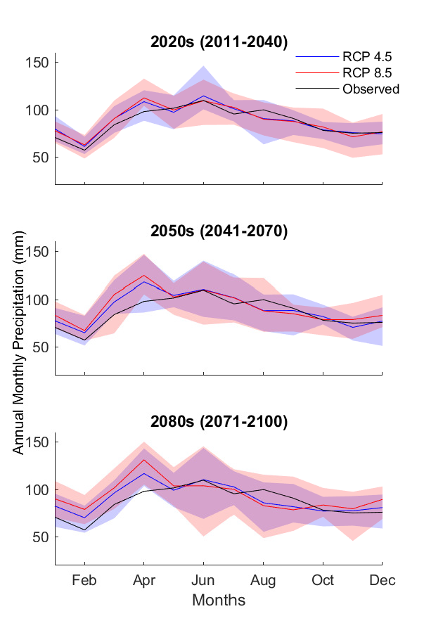
The performance of existing or planned infrastructure to curb stormwater and urban flooding is put into question since the current adopted design may not adequately account for the non-stationary attributes of precipitation extremes in the context of global climate change. This study makes use of the state-of-the-science daily precipitation data through the 2080s provided by Dr.Kyuhyun Byun and Dr.Alan Hamlet at the University of Notre Dame based on statistically downscaled General Circulation Models (GCMs) from the Coupled Model Intercomparison Project Phase 5 (CMIP5), considering different greenhouse gas (GHG) emission scenarios. The city-wide risks of the drainage infrastructure system in the Chicago land area are assessed utilizing a coupled modeling system-MetroFlow developed at the University of Illinois at Urbana-Champaign using a scenario-based approach considering present and projected system capacities. The study also aims to establish a practical and generalizable procedure to assess the impact and/or implication of climate variability and potential climate change at the urban catchment scale accounting for subsurface drainage system utilizing gridded model resolved future precipitation projections, further, to support long-term infrastructure design and planning to mitigate risks.
Supported by MWRDGC
-
Systems Approaches for Vulnerability Evaluation and Urban Resilience (SAVEUR)
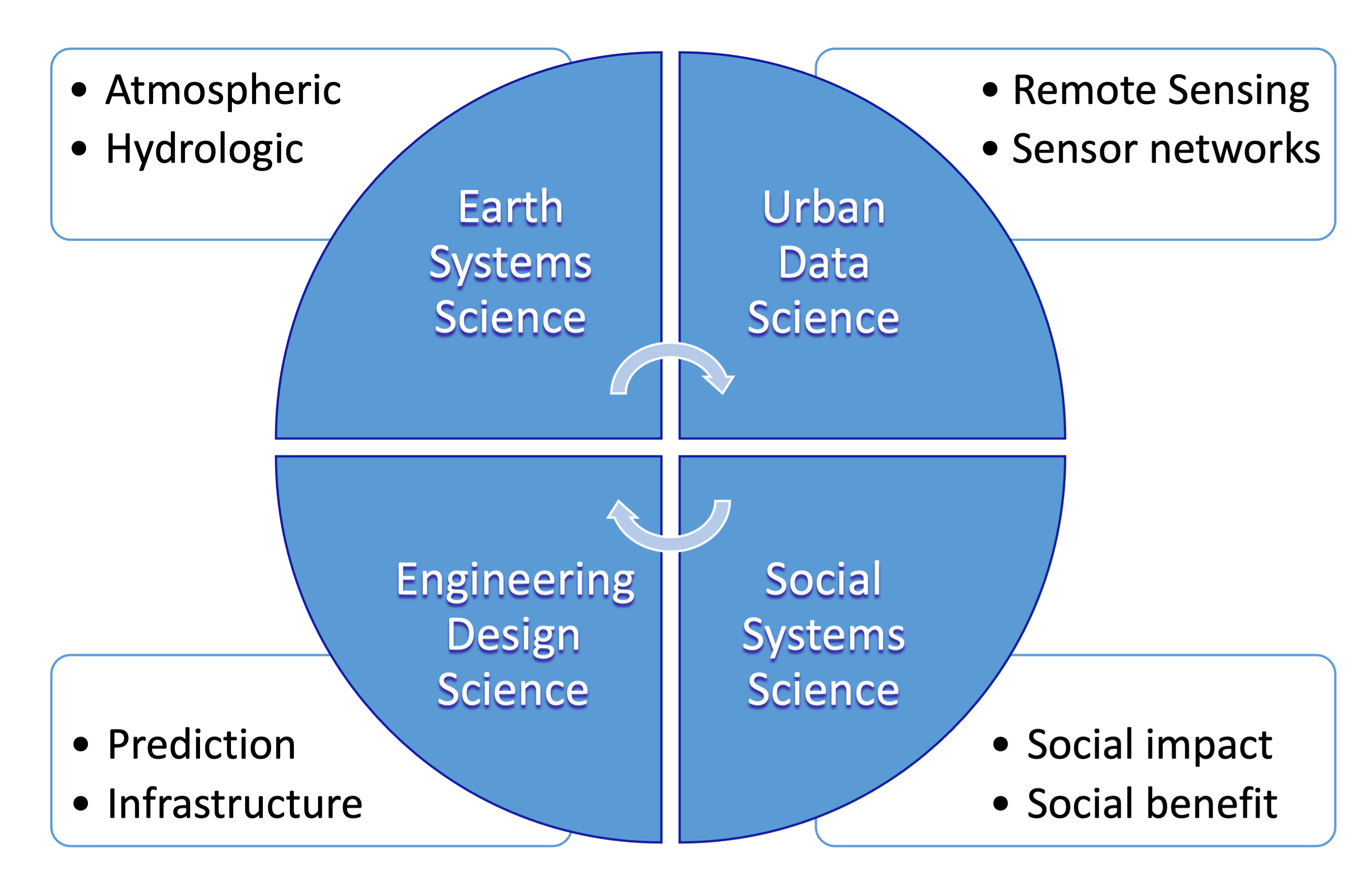
This project combines state-of-the-science earth system models and urban system models in predictive frameworks with in-situ as well as remote sensing measurements ( i.e., Array of Things (AoT)) to assess and reduce the city’s overall vulnerability to extreme weather events, led by Dr. Aaron Packman at the Northwestern University. In collaboration with Northwestern University and Argonne National Lab, we are establishing a multi-level urban convergence approach integrating the data, atmospheric, hydrologic, and social sciences to develop a new holistic urban systems science that seeks to understand and predict inter-relationships between environmental variability, socio-demographic patterns, and the structure of the cityscape. –Learn more
Supported by NSF
Completed Projects
-
Invasive Species Mitigation Alternatives Impacts on the Chicago Area Waterway Systems (CAWS) as it Relates to Flooding, Water Quality and Navigation
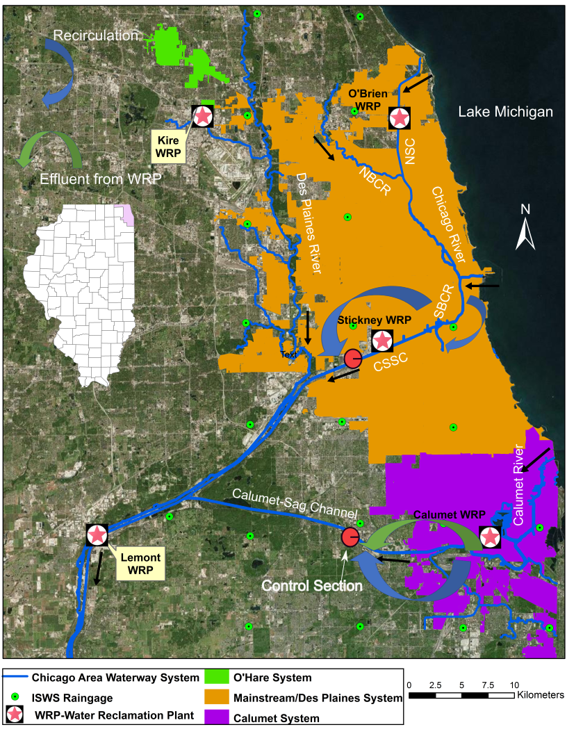
Chicago Area Waterway Systems and combined sewer service areas 
Chicago River Controlling Works, Source: MWRDGC
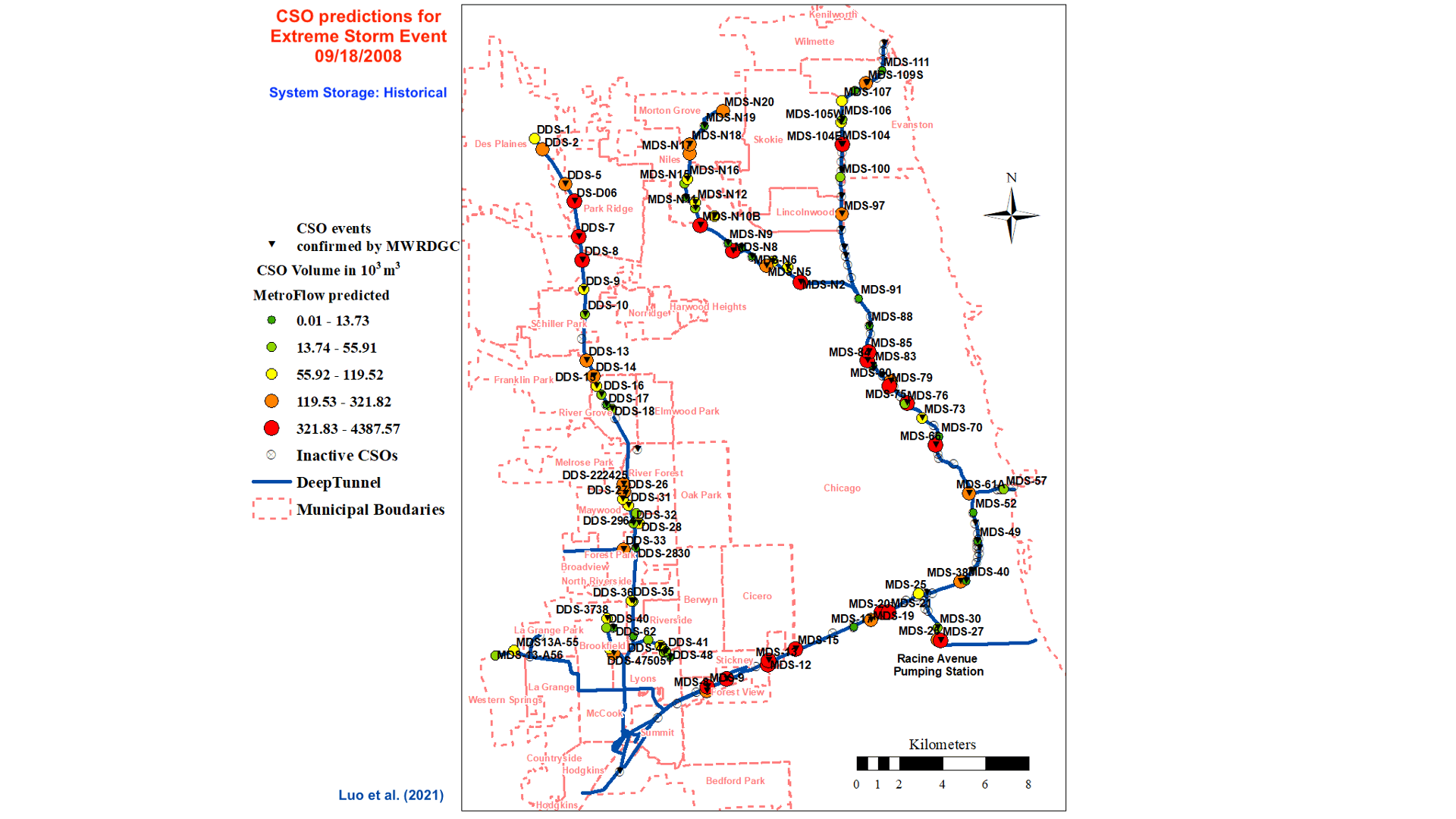
The primary focus of the project is to couple hydrologic and hydraulic modeling of the Chicago areal drainage infrastructure system including combined sewer and Tunnel and Reservoir systems (TARP) with the waterway systems (CAWS) to assess the impacts of storm-driven combined sewer overflows (CSOs) resulting from varying system hydraulic conditions and operational alternatives as well as the mitigation alternatives to prevent the movement of aquatic nuisance species (ANS) on the hydrodynamics and water quality in the CAWS. The work is led by Dr. Marcelo García at the University of Illinois at Urbana-Champaign (2017-2020).
Supported by MWRDGC
-
A coupled CA-Markov and Hydrologic Modeling Approach to Predict Hydrologic Impact in Response to Land Use Shift in Urbanized Watersheds in Qinhuai River Basin.
The project developed and validated a coupled CA-Markov and HEC-HMS model to predict future distributed land use and land cover (LULC) change according to observed long-term observations, as well as the corresponding changes in hydrologic responses with emphasis on floods. The work is led by Dr. Yuqin Gao at Hehai University, China, supported by several agencies, including the National Natural Science Foundation of China. (2018-2020) -
Numerical Investigations of Flow Behavior and Energy Losses at Open-channel Junctions.
This work utilizes 3D Computational Fluid Dynamics (CFD) codes to visualize and understand the Confluence Hydrodynamic Zone (CHZ). The comprehensive 3D numerical investigation highlights the driving mechanisms for junction-induced energy losses and may further enhance the understanding of the primary controls contributing to hydraulic structure-induced turbulent flow behavior and increased hydraulic resistance. The study also shed light on improving the accuracy of 1D large network modeling through the parameterization of the complex 3D feature of the flow field and correction of interior boundary conditions at junctions of large angles and/or with substantial lateral inflows. (2013-2017)Supported by MWRDGC and University of Illinois at Urbana-Champaign
-
Modeling capacity of Upper Des Plaines Interceptor System to accept O’Hare flows.
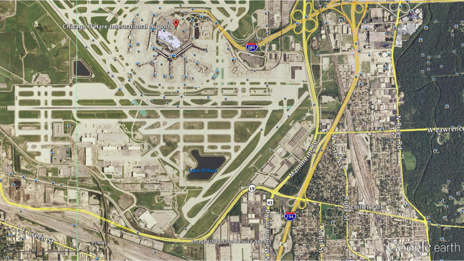
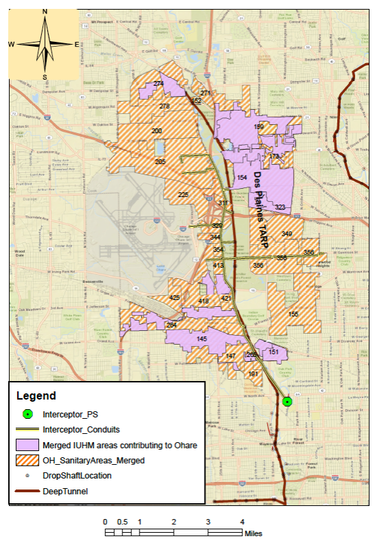
This multi-phase project, led by Dr. Arthur Schmidt and Dr. Marcelo García, developed a numerical model of the Upper Des Plaines interceptor (UDPI) sewer between Rosemont and the lift station near Riverside and determined the available capacity of the Des Plaines tunnel system (TARP) based on model simulations of the system. Further, the developed model simulations were conducted to optimize operational procedures for discharging runoff from O’Hare Airfield to the Upper Des Plaines interceptor sewer and Des Plaines TARP System to identify different scenarios for discharging runoff from O’Hare to TARP and examine the impact of those scenarios on the TARP system, maximizing the flow from O’Hare to TARP while minimizing the risk of adverse impacts on the goals of the TARP system.Supported by Chicago Department of Aviation
-
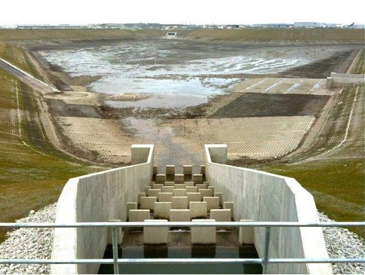
Hydrologic and Hydraulic Modeling of Chicago’s Combined Sewer and Tunnel and Reservoir Plan.
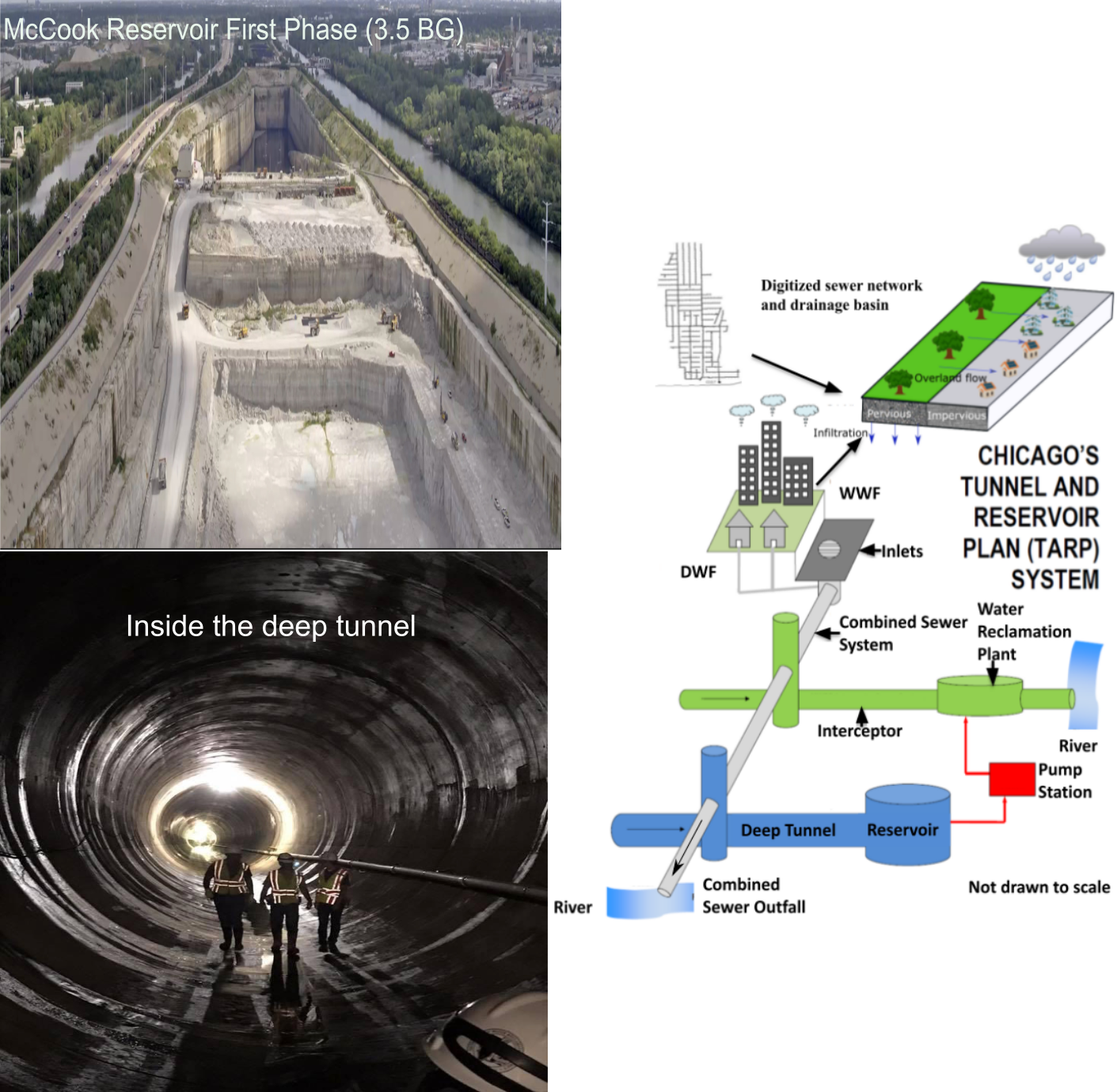
Due to rapid urbanization, the installation of complex infrastructure, and changes in precipitation patterns, urban centers across the United States may be more susceptible to heavy rains and other extreme weather events. Accordingly, there has been the development and evolution of urban drainage infrastructure, which has reached a level of sophistication that is difficult to understand. For example, in order to alleviate the impact of extreme weather events on Chicago, the Metropolitan Water Reclamation District of Greater Chicago (MWRDGC) adopted the Tunnel and Reservoir Plan (TARP) to solve the complex problem of combined sewer overflow (CSO) pollution and flooding in the greater Chicago land area. To provide city managers with tools to better predict the response of the evolving urban infrastructure system to severe weather and changing climates as a whole, the hydrosystems laboratory at the University of Illinois at Urbana-Champaign developed a series of numerical models accordingly to analyze the complex hydraulic behavior of the as-built TARP system. Due to the interconnected nature of the City of Chicago sewer network and the TARP system, a tightly coupled hydrologic and hydraulic modeling program-MetroFlow was developed to facilitate such analysis by integrating multiple models. (2010-2016)Supported by MWRDGC
-
Entropy (Information) Theory Application to Hydrologic/Hydraulic Engineering.
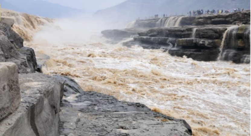
Rapid sediment-laden flow in Yellow River 
Source:USGS The time-averaged velocity distribution in open channel flows is fundamental to hydraulic modeling of flow propagation, sediment and pollutant transport, and river behavior. Distinct from deterministic approaches that usually requires intuitive assumptions to fill in the information gaps about inputs and boundary condition, in this effort, point velocity is regarded as a random variable and, therefore, has a probability distribution due to the inherent system randomness and turbulent flow characteristics. The effort led to the development of a distribution model based on the non-extensive entropy theory that is least biased toward unknown information. (2008-2018)
Supported by Texas A&M University-College Station