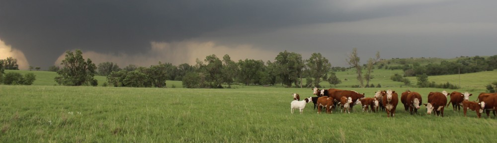
On May 17, we left Champaign early in the morning and headed west. Moisture was nowhere to be seen, and the Storm Prediction Center greeted us with the dreaded “Potential too low” in the Day 4-8 Outlook. Nevertheless, it was the first day of the May 2012 Field Studies of Convection course and spirits were high. After a long drive, we reached Kearney, Nebraska, and called it a night.
On the morning of May 18, we decided that since the purpose of the field course was to observe convection, then we’d observe convection, even if its base was at 500 mb. We saw the text, and headed west from Kearney toward the northeastern corner of Colorado, near Julesburg, where a weak lee trough/dryline and approaching upper-level trough suggested that high-based storms were a possibility.
It is helpful to note that this set up stands as a testament that not every trough in the West brings a severe weather outbreak to the Plains. In this case, a weak upper-level low near Florida led to rising pressures and a collapse of the pressure gradient across the Gulf of Mexico, prohibiting southerly winds and substantial moisture return from the Gulf. To get a severe weather outbreak, not only must the upper-level and surface pattern be favorable, but so must the antecedent environment.

Map showing most of our route on May 18, 2012. Click here for interactive version.
Once near Julesburg, (Point A on the map above), we watched high-based virga showers slowly becomes better developed. Owing to the very deep and dry boundary layer, some of these showers produced downbursts that kicked up blowing dust. Since this was back in the days when I still thought blowing dust was cool, we traveled in a small loop from Julesburg and came close to these downburst winds.

Blowing dust near Big Springs, NE. We’d found out later in the trip that blowing dust is not fun.

Virga (precipitation evaporating before reaching the ground) resulting in a funnel shape in the sky. This was not rotating and was not remotely tornadic. Shot from near Big Springs, NE, looking west.
As we returned to Julesburg, a stronger cell approached from the south. This cell developed into a supercell with a distinct updraft base as it passed nearly overhead. I also was able to film the one of the best looking gustnadoes I have ever seen.

Supercell updraft base viewed from 15 S of Julesburg, CO, looking east.
We left this storm before sunset to preposition for what looked like a much better day tomorrow, and the best day of the next several, owing to the marginal moisture return forecasted across the Plains. On our way south, we stopped for some pictures of the National Weather Service radar in Goodland, KS. In attempt to avoid going through town to get to the restaurants, I navigated us onto what I thought was a shortcut, but ended up being the Goodland cemetery! I guess if you’re going to be DeLormed, it might as well be on the way to dinner when there are no storms around. Hard to tell if this wrong turn or the one we made on May 31, 2013, is more infamous, but, regardless, there aren’t many to choose from.
Following dinner, we drove under the cover of darkness to Garden City, KS, where we spent the night. Overall, a rewarding chase given the marginal conditions.