Mapping Native Land

Fall break is fast approaching and with it will be Thanksgiving! No matter what your traditions are, we all know that this year’s holiday season will look a little bit different. As we move into the Thanksgiving holiday, I wanted to share a mapping project to give thanks and recognize the native lands we live on.

Native Land is an open-source mapping project that shows the indigenous territories across the world. This interactive map allows you to input your address or click and explore to determine what indigenous land you reside on. Not only that but Native Land shares educational information about these nations, their languages, or treaties.  They also include a Teacher’s Guide for various wide age range from children to adults. Users are able to export images of their map, too!

Native Land Map

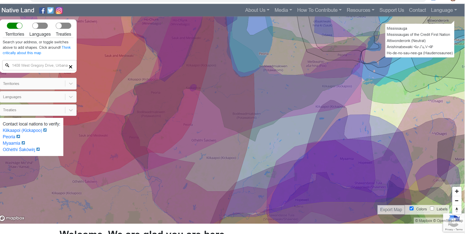
NativeLand.ca Map Interface

Canadian based and indigenous-led, Native Land Digital aims to educate and bring awareness to the complex histories of the land we inhibit. This platform strives to create conversations about indigenous communities between those with native heritage as well as those without. Native Land Digital values the sacredness of land and they use this platform to honor the history of where we reside. Learn more about their mission and impact on their “Why It Matters” page.

Native Land uses MapBox and WordPress to generate their interactive map. MapBox is an open source mapping platform for custom designed maps. Native Land is available as an App for iOS and Android and they have a texting service, as well. You can find more information about how it works here.

If you’d like to learn more about mapping software, the Scholarly Commons has Geographic Information Systems (GIS) software, consultations, and workshops available. The Scholarly Commons webpage on GIS is a great place to get started.

 The University of Illinois is a land-grant institution and resides on Kickapoo territory. Where do you stand?

University of Illinois Urbana-Champaign Land Acknowledgement Statement

As a land-grant institution, the University of Illinois at Urbana-Champaign has a responsibility to acknowledge the historical context in which it exists. In order to remind ourselves and our community, we will begin this event with the following statement. We are currently on the lands of the Peoria, Kaskaskia, Piankashaw, Wea, Miami, Mascoutin, Odawa, Sauk, Mesquaki, Kickapoo, Potawatomi, Ojibwe, and Chickasaw Nations. It is necessary for us to acknowledge these Native Nations and for us to work with them as we move forward as an institution. Over the next 150 years, we will be a vibrant community inclusive of all our differences, with Native peoples at the core of our efforts.

Tomorrow! Big Ten Academic Alliance GIS Conference 2020

Save the date! Tomorrow is the Big Ten Academic Alliance (BTAA) GIS Conference 2020. This event is 100% virtual and free of charge to anyone who wants to engage with the community of GIS specialists and researchers from Big Ten institutions.

The conference kicks off tonight with a GIS Day Trivia Night event at 5:30PM CST! There is a Map Gallery that is open to view from now until November 13th, 2020. The gallery features research that incorporates GIS from Big Ten institutions, so be sure to check it out! There will be lighting talks, presentations, social hours, and a keynote address from Dr. Orhun Aydin, Senior Researcher at Esri, so be sure to check out the full schedule of events and register here.

This event is a great way to network and learn more applications of GIS for research. If you are interested in GIS but don’t know where to start, this event is a great place to get inspired. If you are an experienced GIS researcher, this event is an opportunity to meet colleagues and learn from your peers. Overall this is a great event for anyone interested in GIS and the perfect way to start Geography Awareness Week, which goes from November 15th-21st this year!

Featured Resource: QGIS, a Free, Open Source Mapping Platform

This week, geographers around the globe took some time to celebrate the software that allows them to analyze, well, that very same globe. November 13th marked the 20th annual GIS Day,  an “international celebration of geographic information systems,” as the official GIS Day website puts it.

the words "GIS day" in a stylized font appear below a graphic of a globe with features including buildings, trees, and water

But while GIS technology has revolutionized the way we analyze and visualize maps over the past two decades, the high cost of ArcGIS products, long recognized as the gold standard for cartographic analysis tools, is enough to deter many people from using it. At the University of Illinois and other colleges and universities, access to ArcGIS can be taken for granted, but many of us will not remain in the academic world forever. Luckily, there’s a high-quality alternative to ArcGIS for those who want the benefits of mapping software without the pricetag!

the QGIS logo

QGIS is a free, open source mapping software that has most of the same functionality as ArcGIS. While some more advanced features included in ArcGIS do not have analogues in QGIS, developers are continually updating the software and new features are always being added. As it stands now, though, QGIS includes everything that the casual GIS practitioner could want, along with almost everything more advanced users need.

As is often the case with open source software alternatives, QGIS has a large, vibrant community of supporters, and its developers have put together tons of documentation on how to use the program, such as this user guide. Generally speaking, if you have any experience with ArcGIS it’s very easy to learn QGIS—for a picture of the learning curve, think somewhere along the lines of switching from Microsoft Word to Google Docs. And if you don’t have experience, the community is there to help! There are many guides to getting started, including the one listed in the above link, and more forum posts of users working through questions together than anyone could read in a lifetime. 

For more help, stop by to take a look at one of the QGIS guidebooks in our reference collection, or send us an email at sc@library.illinois.edu!

Have you made an interesting map in QGIS? Send us pictures of your creations on Twitter @ScholCommons!