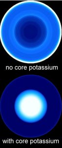
Simulated geoneutrino images of the Earth’s interior.
Center of plot is the nadir direction (underfoot), and outermost circle is horizon.
Two models are shown. In both, uranium and thorium are assumed to be concentrated in the Earth’s crust. In the lower plot, there is potassium and hence the radioistope 40K in the Earth’s core.
We see that in the upper plot without core potassium, the brightest emission is from angles near the horizon, due to the concentration of uranium and thorium in the Earth’s crust. By contrast, in the bottom plot, the core potassium dominates the geoneutrino signal.
Citation: Fields & Hochmuth (2006)


